Trail Walking La Hauteville - La Hauteville - Photo
 raivavae
raivavae

User

© OpenStreetMap contributors
Length
Length
12.5 km
Max alt
Max alt
190 m
Uphill gradient
Uphill gradient
152 m
Km-Effort
Km-Effort  
14.5 km
Min alt
Min alt
141 m
Downhill gradient
Downhill gradient
153 m
Boucle
Boucle
Yes
Creation date :
2014-12-10 00:00:00.0
Updated on :
2014-12-10 00:00:00.0

(1 Reviews)

Walking
Walking
5m
Difficulty : Easy

Scan this QR Code to open this trail in the SityTrail application

FREE GPS app for hiking

Logo SityTrail SityTrail

IGN / Geographical institutes

Download SityTrail from the App Store Download SityTrail from Google Play

Logo SityTrail SityTrail World

The world is yours!

Download SityTrail from the App Store Download SityTrail from Google Play Download SityTrail on Huawei AppGallery

About

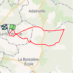
Trail Walking of 12.5 km to be discovered at Ile-de-France, Yvelines, La Hauteville. This trail is proposed by raivavae.

Description

Parking Route du Tartre Gaudran
La Hauteville

Elevation profile

Positioning

Country:
France
Region :
Ile-de-France
Department/Province :
Yvelines
Municipality :
La Hauteville
Location:
Unknown
Start:(UTM)
398273 ; 5395490 (31U) N.

Comments

Please log in to post a review or rate the element


Trails nearby

Trail Walking La Hauteville - HM 2 - Photo
Walking
THERMET

Walking

La Hauteville, Ile-de-France, Yvelines, France
16.2 km | 19 km-effort
1h 23min
No
Trail Walking Senantes - senantes bois de Favrolles  - Photo
Walking
topophil

Walking

Difficult
Senantes, Centre-Loire Valley, Eure-et-Loir, France
11.6 km | 13.5 km-effort
2h 14min
Yes
Trail Walking Boutigny-Prouais - 10663439-Boutigny sur Opton 20.15 - Photo
Walking
togolo28

Walking

Medium
Boutigny-Prouais, Centre-Loire Valley, Eure-et-Loir, France
20 km | 23 km-effort
Unknown
Yes
Trail Walking Adainville - Adainville-Grandchamp - Photo
Walking
raivavae

Walking

Difficult
Adainville, Ile-de-France, Yvelines, France
12.8 km | 15.2 km-effort
3h 18min
Yes
Trail Walking Mittainville - mittainville - Photo
Walking
galou29

Walking

Difficult
Mittainville, Ile-de-France, Yvelines, France
13.3 km | 15.1 km-effort
2h 48min
Yes
Trail On foot Mittainville - mittainville  mittainville - Photo
On foot
CRETTE

On foot

Medium
Mittainville, Ile-de-France, Yvelines, France
24 km | 27 km-effort
6h 6min
Yes
Trail Walking Adainville - M1 Adainville Le Mesle 15 KM - Photo
Walking
papylinlin

Walking

Difficult
Adainville, Ile-de-France, Yvelines, France
15.3 km | 18.1 km-effort
4h 6min
Yes
Trail Walking La Boissière-École - le Passoir Michel - Photo
Walking
Robert28

Walking

Difficult
La Boissière-École, Ile-de-France, Yvelines, France
13.7 km | 15.9 km-effort
2h 52min
Yes
Trail Walking La Boissière-École - La Boissiere École la Butte Mitainville - Photo
Walking
topophil

Walking

Difficult
La Boissière-École, Ile-de-France, Yvelines, France
11.3 km | 12.9 km-effort
2h 45min
Yes


Close
My subscriptions